Trail Walking La Roche-Guyon - La Roche-Guyon boucle - Photo
© OpenStreetMap contributors
Length
Length
15.5 km
Max alt
Max alt
131 m
Uphill gradient
Uphill gradient
299 m
Km-Effort
Km-Effort  
19.5 km
Min alt
Min alt
19 m
Downhill gradient
Downhill gradient
302 m
Boucle
Boucle
Yes
Creation date :
2014-12-10 00:00:00.0
Updated on :
2014-12-10 00:00:00.0

(1 Reviews)

Walking
Walking
4h15
Difficulty : Easy

Scan this QR Code to open this trail in the SityTrail application

FREE GPS app for hiking

Logo SityTrail SityTrail

IGN / Geographical institutes

Download SityTrail from the App Store Download SityTrail from Google Play

Logo SityTrail SityTrail World

The world is yours!

Download SityTrail from the App Store Download SityTrail from Google Play Download SityTrail on Huawei AppGallery

About

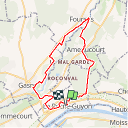
Trail Walking of 15.5 km to be discovered at Ile-de-France, Val-d'Oise, La Roche-Guyon. This trail is proposed by vincentph.

Description

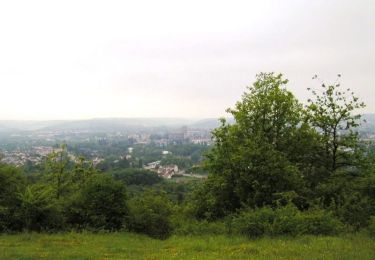
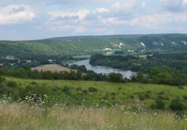
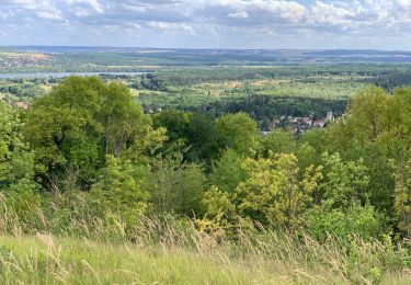
montée vers l'est sur la falaise depuis La Roche-Guyon puis traversée de la forêt vers Fourges, retour via e long de l'Epte puis par la falaise coté ouest.
A faire plutôt avant l'explosion de la végétation.

Elevation profile

Positioning

Country:
France
Region :
Ile-de-France
Department/Province :
Val-d'Oise
Municipality :
La Roche-Guyon
Location:
Unknown
Start:(UTM)
399917 ; 5437364 (31U) N.

Comments

Please log in to post a review or rate the element


très bien à part la portion gasny un peu trop route


Trails nearby

Trail Mountain bike Saint-Martin-la-Garenne - La Garennoise 2005-47km - Photo
Mountain bike
tracegps

Mountain bike

Difficult
(2)
Saint-Martin-la-Garenne, Ile-de-France, Yvelines, France
47 km | 60 km-effort
3h 30min
Yes
Trail Walking La Roche-Guyon - La Roche Guyon - Chérence - Photo
Walking
marcel.F

Walking

Medium
(1)
La Roche-Guyon, Ile-de-France, Val-d'Oise, France
8.8 km | 11.5 km-effort
2h 30min
Yes
Trail Walking La Roche-Guyon - La Roche Guyon - Forêt + falaises - Photo
Walking
marcel.F

Walking

Medium
(2)
La Roche-Guyon, Ile-de-France, Val-d'Oise, France
12.1 km | 15.3 km-effort
3h 22min
Yes
Trail On foot Gommecourt - Accès gr2 - Photo
On foot
PRO

On foot

Easy
Gommecourt, Ile-de-France, Yvelines, France
5.6 km | 6.7 km-effort
1h 31min
No
Trail Walking Haute-Isle - cherence vetheuil  - Photo
Walking
laurentbernardbrunel

Walking

Haute-Isle, Ile-de-France, Val-d'Oise, France
11.1 km | 14.5 km-effort
3h 21min
Yes
Trail Walking La Roche-Guyon - La Roche Guyon  - Photo
Walking
Marie-Claire-mcp

Walking

Very easy
La Roche-Guyon, Ile-de-France, Val-d'Oise, France
8.6 km | 11.4 km-effort
2h 53min
Yes
Trail Walking Saint-Martin-la-Garenne - 160117 - Saint-Martin la Garenne - Photo
Walking
domelisa78

Walking

Easy
(1)
Saint-Martin-la-Garenne, Ile-de-France, Yvelines, France
14.2 km | 15.7 km-effort
3h 27min
Yes
Trail Walking Chérence - 20180311-Les chemins de Sigrancia - Photo
Walking
patb54

Walking

Difficult
(1)
Chérence, Ile-de-France, Val-d'Oise, France
18.1 km | 22 km-effort
4h 49min
Yes
Trail Mountain bike Saint-Martin-la-Garenne - La Garennoise 2005 - 80km - Photo
Mountain bike
tracegps

Mountain bike

Very difficult
(1)
Saint-Martin-la-Garenne, Ile-de-France, Yvelines, France
80 km | 100 km-effort
5h 30min
Yes


Close
My subscriptions